My Favorite Hike In The Great Smoky Mountains: Alum Cave Trail To Mount Le Conte
I really should spend more time in the Great Smoky Mountains.
I went to college in Knoxville, where I lived just a short drive away from America's most visited national park. But now that my husband, Mike, and I live just outside Nasvhille, we don't make it out there as often as we'd like. For our second wedding anniversary, though, we decided to change that.
It was finally time to conquer Mount Le Conte.
At 6,593 feet, Le Conte is the third-highest peak in the Smokies, and it's the highest peak that’s completely within the state of Tennessee. There are five major hiking trails that reach the summit of Mount LeConte, but we chose the Alum Cave Trail, which is the shortest and steepest.
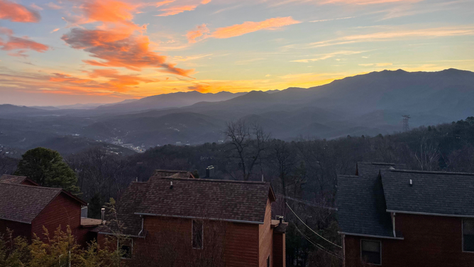
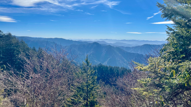
Perfect view of Mount Le Conte from the condo we rented.
(Amber Harding Snyder)
Knowing we were in for a dozy, we made sure to get in a good meal the night before. Y'all, I cannot recommend The Greenbrier Restaurant in Gatlinburg enough. It's a little more "upscale" than casual, but everything we had (including the signature "Dylan" cocktail) was incredible. I'd drive three hours back to Gatlinburg just to eat there.
As I mentioned before, Great Smoky Mountains National Park is the most visited national park in America — to the tune of about 13 million people a year. If you don't like crowds and fighting for parking (and you don't mind bundling up), visiting in the winter months is a great option. We hiked the trail on Feb. 3, and it was nearly empty.
If you're planning to climb Mount Le Conte sometime in the near future (or you're just curious about what it's like), keep on reading! Here's everything you need to know.
Quick Facts: Alum Cave Trail To Mount Le Conte
- MILEAGE: 12 Miles — Out & Back
- ELEVATION GAIN: About 3,100 Feet
- DIFFICULTY: Hard
- PARKING PERMIT REQUIRED: A parking tag is required for every vehicle (except those with a handicap license plate or placard) parking longer than 15 minutes in Great Smoky Mountains National Park. You can buy them online or at any visitor's center in the park. We snagged a weekly pass from a kiosk at Sugarlands Visitor Center for $15 on the way to the trailhead.
- PARKING: Alum Cave Trailhead has two designated parking lots with roughly 70 combined spots. Since we were there on a Monday in February, we had no issues. But during the warmer months and weekends, you'll want to get there early because the spots fill up fast.
- RESTROOMS: There is a bathroom at the trailhead, but it was locked on the day we visited. There is another bathroom near the summit at Le Conte Lodge.
Highlights: Alum Cave Trail To Mount Le Conte
If you read those quick facts, and you're confused right now because AllTrails told you this was an 11-mile hike — not 12 — allow me to let you in on a couple of secrets. First, AllTrails is a lying son of a b*tch. Almost always. Second, we actually ventured just a little bit farther than the summit of Mount Le Conte, and you should, too. More on that later.
The beginning of this trail is a little deceiving. Once you depart from the parking lot, you'll find yourself winding through a peaceful forest, meandering along a babbling brook. In fact, I'm pretty sure this brook is the original inspiration for those soothing nature sound machines that help you fall asleep and calm crying babies.

Styx Branch at Great Smoky Mountains National Park
(Amber Harding Snyder)
It's as if you are Little Red Riding Hood — gleefully marching over the river and through the woods on your way to grandma's house.
But don't get comfortable …because the Big Bad Wolf is coming.
Arch Rock — 1.4 Miles
The first cool landmark along the Alum Cave Trail is Arch Rock, a natural stone formation created during the last Ice Age. As the story goes, an old Smokies wilderness guide named Wiley Oakley first told park services about Arch Rock in 1937, and they decided to route Alum Cave Trail right through it. You'll cross a footbridge over Styx Branch (the actual name of the babbling brook) and then climb the steep staircase through the 20ish-foot opening in the rock.
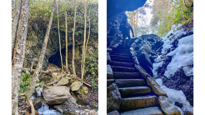
Arch Rock along the Alum Cave Trail
(Amber Harding Snyder)
It was here we ran across a young couple, probably in their late 20s, who were already taking a breather.
"I really want to go all the way to the top of Mount Le Conte," the woman told us. "But I don't know if I can do it."
My husband, being the kind and encouraging human he is, responded: "You've got this. We'll see you up there!"
Spoiler alert: They did not "got this," and we did not see them up there.
Inspiration Point — 2 Miles
Just a little farther, the trail takes a sharp right turn, and you're met with your first breathtaking view of the hike. It's called "Inspiration Point," and from here you can see Sugarland Mountain, Anakeesta Ridge and the Chimney Tops (another popular hiking destination in the Smokies).
This is not the same Inspiration Point where Fonzie, Richie Cunningham, Ralph Malph and Potsie take their lady friends to make out on Happy Days.
But it is a great spot to stop and take photos before you look sweaty and ragged. Because now the real climb starts.
Alum Cave Bluffs — 2.3 Miles
Feeling very inspired, you'll soon hit what looks to be approximately one million stairs. I don't know how many there actually are — I didn't count. But just know you're going to hate life for a few minutes until you come across Alum Cave. It's not really a cave, but "Alum Massive Rock Overhang" doesn't really have the same ring to it.
It is, though, unfathomably large. So large you won't be able to capture it all in one photo. But if you're like me, you'll certainly try. And you'll stand there, leaning back like an idiot playing invisible limbo.
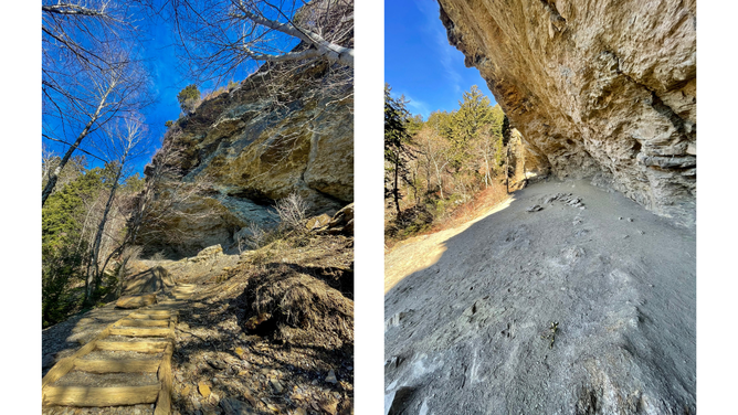
If you zoom in REALLY close, you can see me in the photo on the right. That's how big this rock face is.
(Amber Harding Snyder)
A lot of people cut off their hike here. And if you're short on time (or you're not quite in climbing shape at the moment), there's no shame in that.
If you're not turning around and heading for the parking lot, though, you'd better lock in. Because we're not even halfway to the summit yet.
The Climb
I'm not going to sugarcoat this part for you. This is tough. You are hiking at a very steep gain with no reprieve for nearly 3 miles.
And I can't stress this enough: If you're doing this hike in the winter, bring spikes. Even if the weather is unseasonably beautiful, you were sunbathing by the pool the day before, and you were shedding layers at the trailhead …bring spikes.
Because if this trail is icy:

I had an eye on the forecast for several days leading up to this trip. It was sunny with a high of 70 degrees for our hike. But at the very last minute, I decided to throw some crampons in our packs. And by Mile 4, I was thanking Jesus and Dolly Parton that I did. Ice and snow blanketed the trail at the top of the mountain — so much so that we probably would have had to turn around if we didn't bring micro-spikes for traction.
Or we'd be sliding on our butts the whole way.
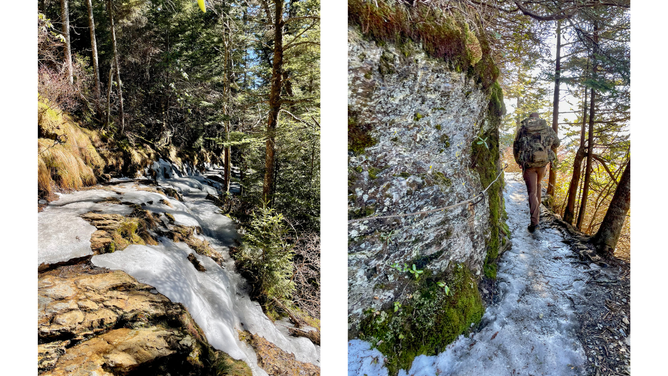
(Amber Harding Snyder)
Once the climb is over, you'll get to the part of the hike that my favorite dorky hiking YouTubers called "the enchanted forest." They're kind of right, though. It's a beautiful tree-lined path, and you definitely won't feel like you're at the top of a mountain. The serenity is a reward for that brutal uphill trek and a nice break for your glutes and hammies, which are undoubtedly screaming at you right now.
Le Conte Lodge — 5 Miles
Le Conte Lodge is what makes this mountain and this trail truly unique. There are 10 cabins on top of the mountain, accommodating a total of about 60 guests. With an elevation of 6,400 feet, it's the highest guest lodge in the eastern United States.
But this isn't your ordinary hotel. There's no electricity on the mountain, so guests at Le Conte have to rely on kerosene lamps to see and propane heaters to keep warm. But your stay includes family-style meals served in the lodge dining room. There is also coffee, hot chocolate and snacks available for day hikers who aren't spending the night. (And restrooms. All the ladies say, hallelujah!)
Unfortunately, the lodge only operates from late March through late November, so we did not get any coffee or snacks on our trip. But the restrooms are open year-round.
Because staying at the Lodge is such a cool and unique experience, it's tough to get a reservation and books up at least a year in advance. So if you want to check it out, you'll have to wait until at least 2026.
Fun fact: A helicopter drops a main shipment of supplies to Le Conte Lodge at the start of each spring. Then, they use llamas to deliver the supplies up and down the mountain throughout the season.
High Top — 5.5 Miles
Just past the lodge, you'll reach the summit — the highest point on Mount Le Conte. And you won't be impressed.
That's because there's no cool view from this point, no way to see through the thick forest of trees. All you'll find at this spot is a pile of rocks. Hikers who come through often add a rock to the stack just to make the summit a teensy bit higher.
I'll stay off my soapbox here, but remember it's generally not a great idea to stack rocks while out on hikes. As responsible outdoorspeople, please always try to follow the principle of "leave no trace."
Now, if you're following AllTrails navigation, this is where it'll tell you to turn around and go back down the mountain. But I'd encourage you to put on your big boy pants and go just a bit farther to Myrtle Point. After all, you're already up here anyway, and I promise it's worth it.
Myrtle Point — 6 Miles
Once you step out on Myrtle Point, you're going to be so happy you walked that extra half mile. This is one of those "holy sh*t" views that goes in your hiker highlight reel. You'll get a nearly-360 look at the Smokies, and there's plenty of empty rock face to have a seat and stay a while.
Mike and I love lunch with a view, so this is where we busted out the Jetboil and freeze-dried pasta. Since it was wintertime, we weren't too worried about a bear sneaking up on us.
Take all the pictures here at Myrtle Point. You earned it. We were very fortunate that another couple arrived shortly after we did, so that we could get a proper photo together. My husband hates asking other people for photos and would rather just take selfies. But a selfie won't do this view justice.
Once you've thoroughly soaked in the majesty (and maybe downed a caffeine shot like I did), it's time for the 6-mile trek back to your car. The good news is — it's, quite literally, all downhill from here.
Post-Hike Beers
An adventure isn't complete without post-hike beers, where we hit up a local brewery and pat ourselves on the back for a job well done.
After the descent, we took our shaky legs over to Smoky Mountain Brewery on the main drag in Gatlinburg. Unfortunately, though, it was closed. Which seems to be a common trend for a lot of places in the Smoky Mountains in February.
So instead, we grabbed burgers and beers at Cherokee Grill right next door — only the fanciest of anniversary dinners for us! Then, we were in bed by 8 p.m. We were too tired to even soak our weary bones in the hot tub.
Alum Cave Trail to Mount Le Conte is not only my favorite hike in the Great Smoky Mountains, but it's also one of my favorite hikes ever. This is not one of those treks where you spend hours looking at nothing just for the privilege of one brief, decent overview. Rather, the entire trail is full of breathtaking vistas every time you round a corner.
(Amber Harding Snyder)
That said, this 12-mile round-trip hike is challenging, and I wouldn't recommend it to pure beginners or to those who aren't in good physical shape. As always, eat a good solid meal beforehand, pack plenty of water, bring a hiking buddy and know your limits.
For those who are up for the challenge, though, Alum Cave Trail to Mount Le Conte is the absolute must-do hike in the Great Smoky Mountains. Do not miss it.
AMBER'S RATING: 10/10
Based in middle Tennessee, Amber is a lover of all things outdoor adventure. Got questions, comments or suggestions for a great hike? Email her at Amber.Harding@outkick.com or find her on Instagram at @AmberHarding.
Love all things hiking and outdoors? Follow OutKick OutDoors on Instagram and TikTok!